Sale on canvas prints! Use code ABCXYZ at checkout for a special discount!


by Duncan Pearson
$28.00
Design Location
Color
Image Size
Product Details
Our Bella / Canvas t-shirts are made from a 50% cotton / 50% polyester blend and are available in five different sizes. All t-shirts are machine washable.
Design Details
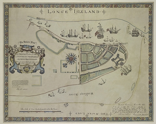
This map shows lower Manhattan Island, parts of Brooklyn and new Jersey as they were in 1664. New Amsterdam was the Dutch Colony proceeding the... more
Ships Within
1 - 2 business days
This map shows lower Manhattan Island, parts of Brooklyn and new Jersey as they were in 1664. New Amsterdam was the Dutch Colony proceeding the British take over. Reproduced 1858.
Duncan Pearson, Aerial Photographer & Author (215) 760-5132 - duncpearson@gmail.com As an aerial photographer I use helicopters and small planes to gain an aerial vantage point. Most of my work is commissioned by the commercial and residential real estate and construction industries. Over the last ten years I've completed custom aerial photography assignments of Brandywine Realty Trust, Harrah's Entertainment, Six Flag's Great Adventure, The Flynn Company, Coldwell Banker Preferred, Madison Development, Liberty Property Trust, The University of Pennsylvania and many other corporations and institutions. Fine Art America is the best way I've found to make it easy for my patrons to navigate to the pieces they are interested in and...
$28.00


There are no comments for The Dukes Plan a Description of the Town of Mannados or New Amsterdam 1664. Click here to post the first comment.